Responsible Travel in Madagascar

From the capital to Moramanga
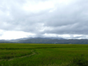
After the hustle and bustle of the capital, the trip to Moramanga allows first-time visitors to Madagascar to discover traditional rural life. Rice fields, hotel restaurants, and seasonal fruit stalls along the roadside offer opportunities to observe the daily activities of the vast majority of Malagasy people living outside the big cities.
The 10 km road leading to Ambohimangakely is surrounded by rice fields which, in the early morning, are filled with people engaged in the essential activity of providing their families with rice: digging, sowing, transplanting, weeding, and harvesting. The next 20 km take you through the town of Ambohimalaza, steeped in history and tradition. Shortly after passing through the small village of Nandihizania (PK 28) and the curiously named town of Carion, you can relax knowing that it is downhill for the rest of the journey, as the PK 36 marker marks the highest point of the RN2 at an altitude of 1,570 meters.
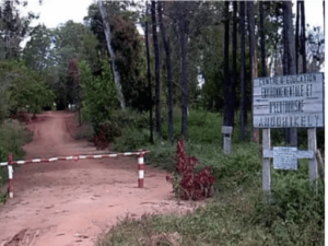
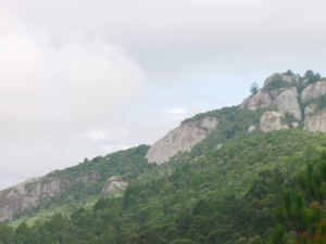 South of the road is the Angavokely Forest. This is one of the closest protected tropical forests to the capital (about 35 km away), but it is surprisingly little visited; there is a good chance that visitors will have the place to themselves.
The granite landscape covered with forest is home to 120 species of orchids, a wide variety of birds, and other wildlife in a protected area of 690 hectares. There are also five caves that can be explored with a guide.
In the same region, about 12 km south of Carion, lies the traditional rural village of Ambatomanga.
As the highland mountains recede behind you, the road to Moramanga takes you through numerous small villages and sparsely populated stretches of countryside, with occasional charcoal sellers along the way.
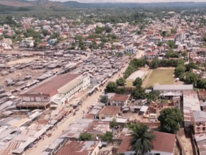 There are several ways to translate the name of this city: "mora" means slow, easy, cheap, or sweet, and "manga" means blue, beautiful, mango, or (when referring to livestock) wild. It is also believed that "manga" was a slang term for slaves. So, while many say that Moramanga simply means "cheap mangoes," others believe that the city has a darker history as a trading post for "cheap slaves."
Whatever the origin, the first explanation is more logical today, as the large market is thriving on fruit at reasonable prices, with fortunately few traces of human captives!
This is a popular stop for public transportation and trucks; traffic is heavy day and night, and hotel rooms facing the street can be noisy. The upside is that there is always a restaurant open.
Heading north or south from Moramanga, you will find yourself at a crossroads. To the north, the RN44 leads to Lake Alaotra, described below. To the south, a rough but interesting road leads to Anosibe an’Ala and the Chutes de Mort, a large waterfall located 53 km from Moramanga.
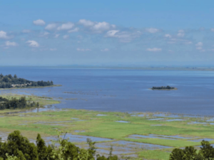 More than half a million people now live around the lake., and deforestation has silted it up so that its maximum depth in the dry season is now only 60 cm. The introduction of exotic fish has further aggravated the situation. However, all is not lost; an environmental campaign led by the Durrell Wildlife Conservation Trust has restricted fishing and banned the burning of marshes and the hunting of lemurs. The local population now recognizes the role that marshes play in providing water, a spawning ground for fish, and weaving materials for basketry, which is an important source of income in the region..
In 2006, the area was granted protected status and an ecotourism project was developed to give tourists a chance to see one of Madagascar's most beautiful landscapes.
The soft-tailed lemur of Lake Alaotra is an endangered species. Annual monitoring has shown that lemur populations have stabilized and fish catches are increasing.
The drive around the lake takes at least a full day and takes you through village after village where rice, livestock, fishing, and geese, as well as tomatoes and onions, are the essentials of rural life.
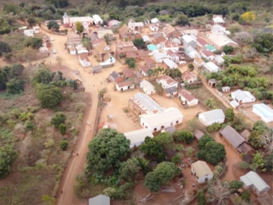
AMBATONDRAZAKA
 On the southeast shore of the lake, it is the main town in the region and a good base for excursions. Its name means "the place of Razaka's stone"; legend has it that Razaka was one of the three children of a local elder named Randriambololona. Razaka, who was orphaned, took charge of his sisters' children and marked the adoption agreement with a sacrifice on a small oblong stone. The original stone has long been lost, but a replica was installed in 1976 on the original site and can be seen today at the southwest corner of the rather grandiose Sacred Heart Church. Razaka's two sisters, Rasaheno and Ramiangaly, have been commemorated in the names of two nearby hills: Ambohitseheno and Ambohimiangaly.
Market day is Saturday.
AMBOHITSILAOZANA
 In this village located about 15 km north of Ambatondrazaka, there is a forest station long-established community called Ambohikely, a 17-hectare isolated forest plot that is home to a large colony of flying foxesYou can follow a 2 km trail northwest to a viewpoint overlooking the lake.
The Alaotra Lake Agronomic Center (CALA)
This is a Swiss botanical research cooperative with a weather station that has collected nearly a century of data. Ask nicely and they will show you the library with over 200 meters of sagging shelves laden with dusty tomes dating back over 130 years. The room also houses a taxonomic museum of local species with around 100 stuffed specimens (mainly birds). The extensive grounds—which are unfortunately no longer maintained—include a long avenue of eucalyptus trees, another with several species of bamboo, and a third with numerous species of lychee.
ANDREBA IN IMERIMANDROSO
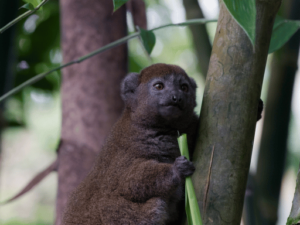 9 km further on is the village of Andreba. Be sure to stop there to visit the Bandro ParkBandro is the Malagasy name for the rare and locally endemic sweet lemur of Lake Alaotra. To have a chance of seeing them, you need to book a pirogue excursion, as this is the only lemur that lives in an aquatic habitat of reed beds. The best time to visit the park is from March to June, when the water level is at its highest. You must leave before dawn and therefore spend the night at Camp Bandro, located nearby.
Just after Andreba is the village of Ambatosoratra—short for the original name Ambatosorapanorompondradama, which means "the place of Radama's fanorona stone," because it is said that the king once stopped here to play this Malagasy chess game.
Continuing 9 km north, you arrive at Ambohidava, which was once the terminus of the railway line. There are no plans to reopen the Ambatondrazaka-Ambohidava section, which is just as well, as the station has been replaced by a primary school and dozens of residents have built their homes directly on the tracks.
 After 13 km, you will come to a fork in the road on the right, where a 2 km track will take you to the charming little Tsarahonenana village, with its old church dating back to 1869. 500 meters north of the village is a fortified site from the early 19th century called Anatalonty, but you must ask permission before visiting it, as it is now a private family home. The military chief of King Radama I, Ralakomanana, lived there; you can still see his tomb and those of his two wives.
Back on the main road, a left turn will take you 2 km to the peaceful lakeside village of Vohitsoa, where the women are renowned for their basketry work. From there, it is only 4 km to Imerimandroso (market day on Mondays), which offers a panoramic view of the lake and the island of Nosy Ambatonakatrana, where the inhabitants of Imerimandroso took refuge when Radama I invaded their town. It is not possible to live there, but there are several tombs, including one that is over 20 meters long.