Responsible Travel in Madagascar

Not to be confused with the Kirindy Reserve, which is more famous and easier to access.
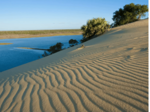 Kirindy-Mitea National Park protects a wide variety of habitats—including mangroves, dunes, lakes, and beaches – but only welcomes a small number of visitors. The park entrance is located in Manahy, 15 km southwest of Belo.
An area centered on the two lakes, Ambondro and Sirave, was declared a Ramsar Wetland of International Importance in 2015. These lakes are particularly interesting because they are known to the local population and have not been disturbed for generations.
 The less mythological wildlife that tourists are more likely to encounter includes most of the lemur species found in the Kirindy Reserve or Andranomena, as well as ring-tailed lemurs (this is the northern limit of their territory).
The park is a veritable kingdom of baobabs, with three species and a density of these trees unmatched anywhere else. The lakes near Manahy are home to more than 30 species of birds (many of which are rare) and endangered waterfowl. A marine area is also part of the park, where dolphins can frequently be seen, especially from July to September.
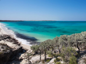
It is an isolated but extremely rewarding village; a very different experience from beach resorts such as Ifaty and Anakao.
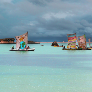
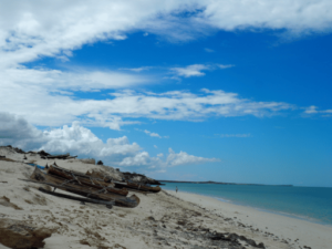
 It is a place where you can truly experience the local culture and see the lives of fishermen unchanged for centuries. It is theone of the largest fishing communities on the southwest coast and, in calm weather, the fleet of outrigger canoes setting out to fish at dawn is a magical sight.
The region boasts the richest marine ecosystem on the southwest coast, and has therefore become home to many migrant fishermen, as well as a rapidly developing tourist resort. Manta rays and turtles are regularly sighted, with seasonal migrations of humpback whales between June and October, and phenomenal megapodes of up to 500 dolphins have also been observed in recent years. The region is the main base for the marine conservation organization Blue Ventures (it has contributed to the training of local "eco-guides" whose services can be requested at the Blue Ventures research and conservation center, located at the southern end of the village).
 About 1½ hours by canoe south of the village is Assassins' Bay, which makes for a good excursion. You can also get there by zebu cart in about an hour. Near the bay, you can visit Blue Ventures' aquaculture projects (community farming of sea cucumbers and red algae). In the same area, there is a spider crab breeding project. The eco-guides can organize an excursion. They can also take you to a forest of Grandidier's baobabs, which are strangely stunted and almost spherical.
Less than 5 km south of Andavadoaka lies the small village of Ampasilava. Between the two villages is the Laguna Blu Resort, owned by an Italian doctor who built a hospital nearby. The hospital has a very good reputation locally, and people come from far and wide to seek treatment there.
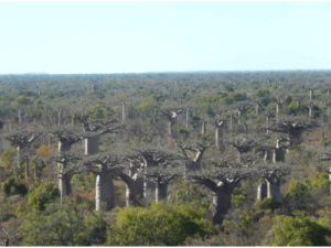
AVENUE OF THE BAOBABS
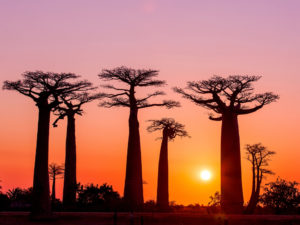 This group of Grandidier's baobabs (Adansonia grandidieri) is theone of the most famous views in MadagascarIn 2007, the avenue (along with approximately 300 baobab trees of three species in the surrounding 320 hectares) became an officially protected natural monument. There is a parking lot, a paid tour, a souvenir shop, an information office, and a nursery, with an active program of planting young trees among the existing trees.
To reach the avenue, turn left onto the RN35, about 14 km from Morondava, and the baobabs are 6 km further on. It takes about 40 minutes by car, or you can come by bike or quad bike.
 The best light for photography is just before sunset (it brings out the red hue of the bark), but sunrise is almost as good, and you're less likely to have crowds of tourists in the background of your photos.
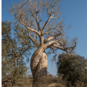
LOVING BAOBABS
These "loving" baobabs (Adansonia za), so named because they form a romantically intertwined pair, have become almost as famous as the Avenue of the Baobabs itself. Turn left 3.5 km north of the avenue and you will find them 3.5 km further along this track. You can see another pair intertwined in the same way at Camp Amoureux.
 It is theone of Madagascar's most rewarding natural areas and part of the Menabe Protected Area 125,000 ha (not to be confused with Kirindy-Mitea National Park above).
Until about ten years ago, its sole purpose was the sustainable harvesting of trees.
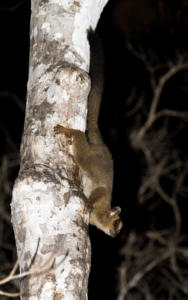
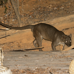 It is one of the few places where you can see the giant jumping ratr and the narrow-striped mongoose, and it is also the best place in Madagascar to see the fossa.
Reptile watching is excellent: you can see collared iguanas searching for open sandy areas to lay their eggs, while flat-nosed snakes eagerly sniff out these freshly laid snacks, dig them up with their snouts, and swallow the eggs whole.
It is highly recommended to schedule a night walk. Daytime visitors see much less than those who can observe wildlife at the optimal times of dawn and dusk, and a night walk is usually an exceptional wildlife experience, with nocturnal lemurs and chameleons easily observable and—if you are lucky—a giant jumping rat.
The turnoff for Kirindy is located 61 km (2 hours) northeast of Morondava and 42 km (1½-2 hours) south of Belo-sur-Tsiribihina, on a road that can become impassable during the rainy season. From the turnoff, it is another 5 km to the ticket office and parking lot.
Beyond Kirindy, most of the area between the road and the coast is classified as a wetland of international importance under the Ramsar Convention, divided into two sections managed by FANAMBY and WWF.
The shallowLake Bedo and the surrounding marshes form a 2,000-hectare site protecting Bernier's teal, Humblot's heron, Madagascar plover, the greater and lesser flamingos, lemurs, turtles, the critically endangered Madagascar box turtle, crocodiles, and a rich variety of vegetation.
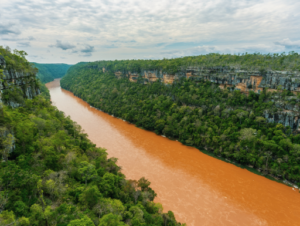
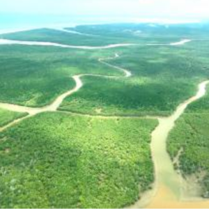 Immediately north of this site, and stretching 48 km across the Tsiribihina River delta to Belo and beyond, lies the Tsiribihina Mangroves site, which was created in 2017 and covers more than 47,000 ha. Nearly half of this area consists of mangroves – representing more than 8% of Madagascar's mangrove forest. – and the rest consists of lagoons, sandbanks, salt marshes, mudflats, and swamps. Some 44 species of water birds live there, including the Madagascar fish eagle and the Madagascar sacred ibis, as well as Verreaux's sifakas, hawksbill turtles, and Madagascar flying foxes.
In the heart of the mangrove forest of Tsiribihina – and an ideal base for exploring it – is the excellent Lodge de la Saline. This is an ecolodge built with natural materials and using solar energy in its 16 air-conditioned bungalows with bathrooms.
 77 km beyond the avenue of the baobabs (or 97 km from Morondava), you will reach the banks of the Tsiribihina River. There is no bridge, so to continue further, you will need to take a motorized raft that will take you to a landing point 6 km downstream. This should take no more than half an hour (but the return trip may take twice as long because the ferry has to go against the current) and brings you to a point just 2 km from the center of Belo-sur-Tsiribihina.
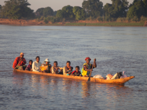
Instead of driving to this point, some people choose to access the Menabe region by traveling down the Tsiribihina River from the highlands. The town of Miandrivazo (240 miles by road from Antananarivo) is the gateway for this descent, where you can make the necessary arrangements.
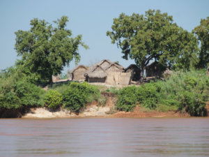 From Miandrivazo, it is a two-hour drive to the Masay camp, where you join the river. The descent takes three to five days and ends in Belo. During the dry season, you will camp on sandbanks, but if you come during the rainy season, you will spend the night in villages. Most people enjoy this trip for the wildlife seen from the boat (mainly birds) and for the glimpses of rural life on the riverbanks..
Be aware that some boats have less shade than others, so bring adequate sun protection and plenty of water, and pack your bags to protect sensitive items. When camping, if you have to use a sandbank as a toilet, be sure to bury your waste properly. And don't forget to take all your waste with you.
Tsiribihina means "where you shouldn't dive"—because of the crocodiles, of course!
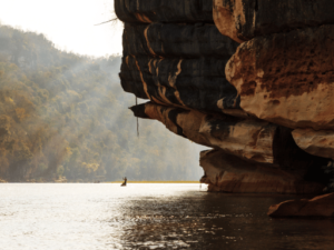
 After traveling 92 km north from Belo, you arrive at another river. This time, the ferry crossing is quicker because the boarding ramps are directly opposite each other. As you cross, you have a view of the spectacular Manambolo Gorge which mark the southern boundary of the national park the Tsingy of BemarahaThe village at the park entrance is Bekopaka, located immediately across the river.
As with Tsiribihina, it is possible to reach Bekopaka by traveling down the Manambolo River from the highlands. This trip usually takes three days (but five days allow for rest and sightseeing) and starts in Ankavandra, west of Antananarivo. It is a spectacular journey through the unspoiled lands of the Sakalava. There is a good chance of seeing the region's unique wildlife, such as Decken's sifaka and the Madagascar fish eagle.
Bekopaka
 This village on the banks of the Manambolo River is located at the southwestern corner of the national park. Tsingy of Bemaraha. Ticket offices and tourist accommodations are located on the outskirts of Bekopaka. Access to the region is virtually impossible during the rainy season (usually from late November to April), so the park and hotels close during this period.
Even in the best of times, much of the road from Morondava is terrible. Unless you can afford to charter a plane to the dirt airstrip (17 km/45 minutes northwest of Bekopaka via a road in poor condition), there are essentially three options for getting here: by 4×4 from Morondava (197 km/8-10 hours); a three- to five-day trip down the Tsiribihina River from Miandrivazo to Belo-sur-Tsiribihina, then by 4×4 from there (94 km/4-5 hours); or a three- to five-day trip down the Manambolo River from Ankavandra directly to Bekopaka. As the rivers are not easily navigable against the current, the only option for leaving Bekopaka is the road to Morondava.
For backpackers whose budget does not allow them to hire a 4×4 and driver for a few days, the options are limited. There is very little public transportation from Morondava, and if you choose this option, you will not be able to stop at the Avenue of the Baobabs and the Kirindy Reserve along the way.